Editor’s Note: A snow squall warning was issued for parts of the Chicago area, and a ground stop at O‘Hare was in place through 8:45 a.m.
After days of mild temperatures, snow is back in the Chicago-area forecast, with multiple rounds possible over the next few days starting with the chance for as much as 12 inches in parts of northwest Indiana where winter storm warnings and advisories were in effect.
In northeast Illinois, upwards of an inch of snow was expected Wednesday, the NBC 5 Storm Team said, followed by more area-wide snow Thursday.
Early Wednesday morning, Live Doppler 5 radar showed the system hovering over southeastern Wisconsin and moving into Illinois’ far northern counties. The snow will continue to build over the next few hours, NBC 5 Storm Team Meteorologist Alicia Roman said, before it transitions to lake-effect snow in Indiana where it will stay “pretty much all day long.”
As the system continues to move into the Chicago area, here’s a breakdown of what to expect and when.
Winter storm warnings, advisories Wednesday
As the system moves south, gusty, scattered snow showers will fall in Illinois and southeastern Wisconsin through about 12 p.m., Roman said
“Be prepared for a possible slowed and slippery A.M. commute due to localized drops in visibility, quick coating of snow in sports and gusty winds,” the National Weather Service said.
Later Wednesday morning, the NWS issued a snow squall warning for some Chicago-area counties, with drivers reporting deteriorating road conditions.
On the other side of Lake Michigan, in LaPorte County, a winter storm warning was in place through 1 p.m. Thursday, with between six and 12 inches of heavy, lake effect snow possible.
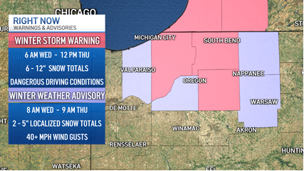
“Locally higher amounts are possible,” the NWS warned, “especially in Berrien County, Michigan.”
Winds gusting as high as 40 mph with blowing and drifting snow was expected to create whiteout conditions, making travel “treacherous and potentially life-threatening,” the NWS added.
Those conditions were expected to last Wednesday evening and into Thursday morning, the NBC 5 Storm Team said, as lake effect snow lingers.
In Kenosha County, a winter weather advisory was in effect until 10 a.m. Wednesday, with officials warning of slick and slippery roads. A winter weather advisory was also in effect for Porter County in Indiana, with hazardous travel possible and total accumulations between two and five inches.
“The worst travel conditions will be between 5 p.m. and 8 a.m.,” the NWS advised. “Alter your travel plans if possible.”
Temperatures Wednesday were also expected to plummet down to the 20s, with the warmest part of the day in the morning.
“Definitely turning a lot colder for your Wednesday,” Roman said.
More rounds of snow Thursday and beyond
Lake effect snow in Indiana was expected to come to an end by lunchtime Thursday, Roman said. After that, a “wintry pattern” will bring daily chances for snow, blustery winds and cold temperatures.
An arctic front will arrive late tonight accompanied by snow showers and a start of lake effect snow in northwestern Indiana. A wintry pattern will then prevail through at least early next week with regular opportunities for snow, blustery northwest winds, and cold temperatures. pic.twitter.com/ffuaWH7vwn
— NWS Chicago (@NWSChicago) January 13, 2026
“We’re watching another fast-moving system that will bring us more snow area-wide Thursday night,” Roman said, starting at about 5 p.m. That system could bring as much as two inches, Roman said.
Temperatures will be in the 20s Thursday and 30s Friday, before dropping into the teens over the weekend and for Sunday’s Bears-Rams playoff game at Soldier Field.
This story uses functionality that may not work in our app. Click here to open the story in your web browser.
![]()
Want more insights? Join Working Title - our career elevating newsletter and get the future of work delivered weekly.
