A “parade of systems” is expected to hit the Chicago area this week, bringing a number of weather threats amid what has been a historic start to winter.
According to the NBC 5 Storm Team, there will be chances for rain, freezing drizzle and snow all before another arctic blast is set to arrive.
The wintry weather follows a round of accumulating snow over the weekend that brought the area totals for the season so far to more than 17 inches in the region.
There is some good news for those surprised by the winter blast.
Temps are expected to begin warming up briefly Tuesday and Wednesday, with highs reaching into the upper 30s.
Tuesday marks the next chance for precipitation with some wet weather moving in just in time for the afternoon and evening commutes.
There is a chance that temps stay cold enough to lead to freezing drizzle at the start, which could make for hazardous travel, before the precipitation transitions to all rain through the evening.
The National Weather Service said a clipper system will remain north of the area through midweek, “allowing above freezing temps to return Tuesday along with gusty winds and rain.”
Another chance for light snow or flurries arrives Wednesday morning.
Periodic snow chances will continue through the end of week as temperatures plummet.
Thursday, highs drop back into the 20s and continue falling from there, with more snow dusting chances in the evening.
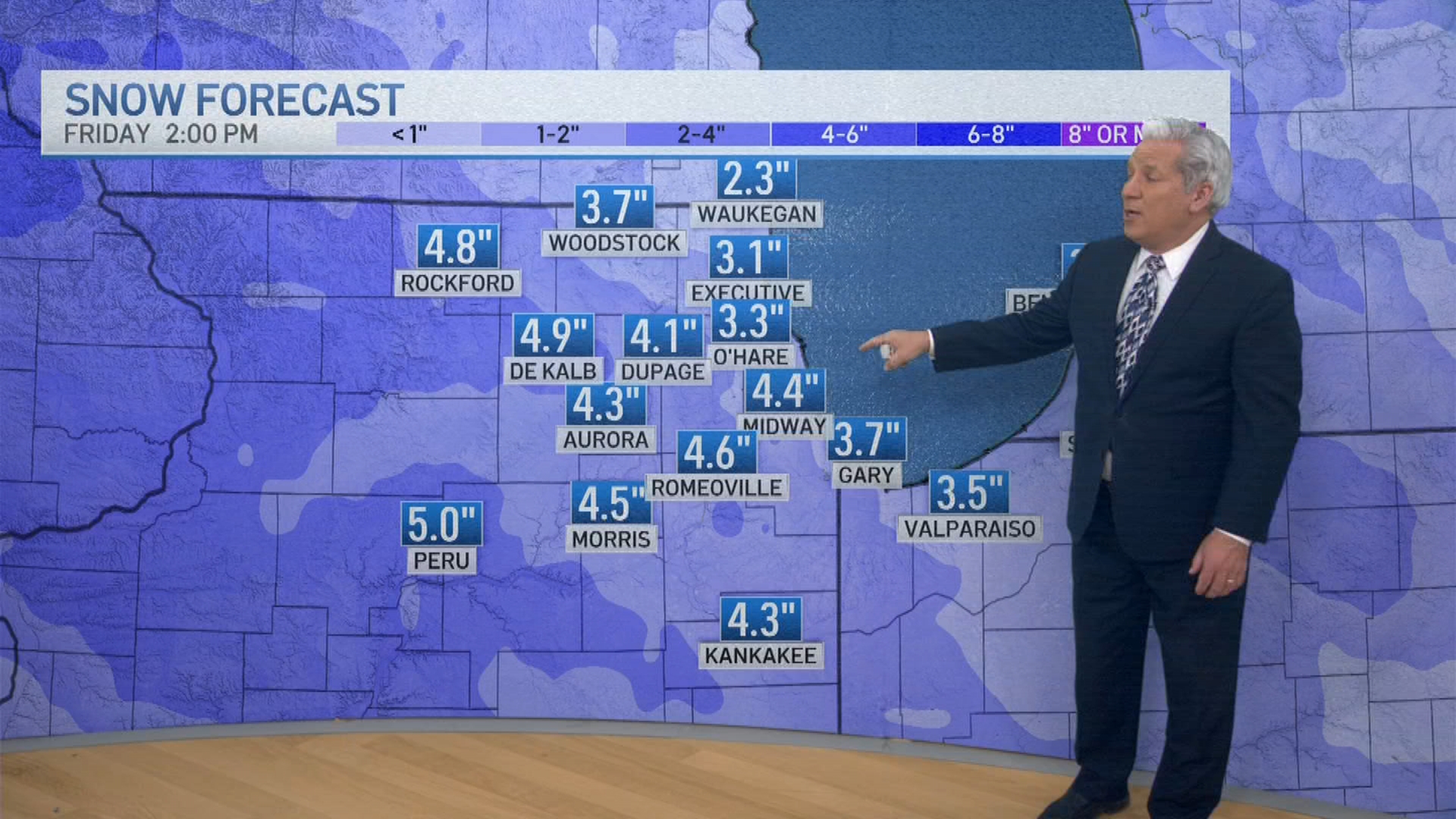
On Friday, more snow could arrive, according to NBC 5 Storm Team Meteorologist Pete Sack.
“We could get a couple inches out of it,” Sack said, with some areas seeing between two and four inches.
Then comes another arctic blast as highs drop into the teens and near single digits, with below-zero wind chills possible by the weekend.
Snow chances continue Saturday, with a high of just 10 degrees, Sack said.
The multiple chances for snow throughout the week and weekend could lead to as much as five inches of snow by Sunday, forecast models showed, with even higher amounts possible to the southeast and in northwest Indiana.
The area’s snowy start to December has been unusual. So far, 17.1 inches of snow has been recorded in Chicago as of Dec. 7. During the entire 2024-25 winter season just 17.6 inches of snow fell in the area.
It marks the snowiest start to winter since 1978, according to NWS. That year, 24.1 inches of snow had fallen by Dec. 7.
This story uses functionality that may not work in our app. Click here to open the story in your web browser.
![]()
Want more insights? Join Working Title - our career elevating newsletter and get the future of work delivered weekly.
