The Chicago area Thursday woke up to a foggy morning, with pockets of drizzle gradually coming to an end but cloudy skies expected to linger through the day, the NBC 5 Storm Team said.
Temperatures, however, were still above average, with highs in the mid 40s to mid 50s. But by this time next week, a major change will have arrived.
“35 degrees on Thanksgiving,” NBC 5 Storm Team Meteorologist Alicia Roman said. “33 degrees on Black Friday.”
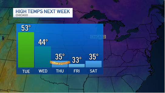
Before that, temperatures will remain on the mild side, with a high temperature of 51 degrees expected Friday. The weekend will be much sunnier, Roman said, with a high of 50 degrees Saturday, and 56 on Sunday.
“The weekend looks great,” Roman said.
Temperatures stay mostly in the 50s through early next week, with “soaking” rain possible Tuesday morning, Roman said. By Wednesday, temperatures will have dropped into the 40s, and then plummet into the 30s for Turkey Day and beyond.
“It’s expected to get much colder in the Chicago region around and after the Thanksgiving holiday,” NBC 5 Storm Team Meteorologist Kevin Jeanes explained. The drop in temperatures, Jeanes said, is caused both by ridging in the jet stream in the Pacific Northwest and potentially something called a “Sudden Stratospheric Warming” (SSW) event.
“An SSW is when large-scale waves in the atmosphere, called Rossby waves, get pushed higher into the atmosphere,” Jeanes said. “This causes air to sink and warm rapidly around the polar vortex, which can dislodge and send the cold air southward into the mid latitudes, rather than staying bottled up near the North Pole.”
Jeanes added that an SSW in November would be unusually early in a season.
Tuesday, the National Weather Service’s Climate Prediction Center said the “rare” November SSW, combined with other effects including La Niña, means a colder weather pattern change is “likely” for the west, north and Central Plains, with much of the central and northern U.S. transitioning to a colder pattern by early December.
That change favors more winter-like conditions across the central US, the forecast stated, “including much below normal temperatures and the potential for heavy snow.”
Snow chances look limited through November, Jeanes said, with bigger chances for the first or second week of December.
As we get closer to that timeline, Jeanes said, the jet stream will dictate the snow’s track.
“Early signs are showing some moderate snow staying south of the Chicago area through the end of November,” Jeanes said, “but there are signs we get one or two potent snow-producing storms in the first week or two of December.”
This story uses functionality that may not work in our app. Click here to open the story in your web browser.
![]()
Want more insights? Join Working Title - our career elevating newsletter and get the future of work delivered weekly.
