What to Know
- NBCLA will provide live storm coverage updates above throughout the morning.
- Flash flood warnings were issued early Saturday through noon for parts of Los Angeles County, including Malibu, Compton, Inglewood, Glendale, Altadena and other communities.
- Some of the warnings expired late Saturday morning, but others continued into the afternoon.
- Showers will linger through the weekend with a chance of rain early next week.
- If Los Angeles receives more than 2.43 inches of rain Saturday, this will be the wettest November on record. The current mark was set in 1985.
- Half of California is drought-free in mid-November with pockets of moderate to severe drought in Southern California.
The second wave of a mid-November storm delivered steady rain Saturday in Southern California, raising the threat of flooding and debris flows in the region’s recent wildfire burn areas.
Widespread parts of Los Angeles County were under flash flood warnings throughout the morning as the brunt of the storm brought heavy rainfall to Malibu before dawn before drenching other areas. Some of the flash flood warnings expired before noon, but others are expected to remain in effect into the afternoon, Including in Malibu, Santa Clarita, Pasadena, El Monte, Santa Monica, Calabasas, Agoura Hills, Pomona and Diamond Bar.
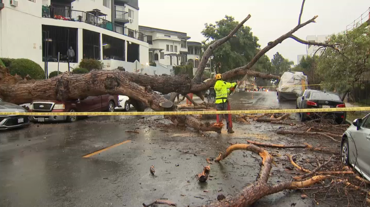

Several inches of rain fell in Malibu by Saturday morning, when lightning flashes could be seen off the LA County coast.
Evacuation orders were in effect for some properties considered at high-risk for debris flows in the Palisades, Eaton and other fire zones. Evacuation warnings were in place for other burn areas, meaning residents should be prepared to leave.
The system, which could also produce thunderstorms, hail and even small tornadoes, moved into Santa Barbara and Ventura counties Thursday night and brought scattered showers to Los Angeles County Friday. Flood watches were in effect and through Saturday night for parts of Los Angeles, Orange, San Bernardino and Riverside counties.
About 23 million people are under some type of flood alert on Saturday.
Here’s what to know about the mid-November storm.
Storm timeline
Steady rain brought increased threats for flooding and debris flows Saturday morning. A large swath of Los Angeles County was under a flood watch in effect until 8 p.m. Saturday. Expect moderate to heavy rain between 5 a.m. and midday.
- Midday and Saturday afternoon: Rainfall rates reach their peaks with an increased chance for thunderstorms. Flood watches were in effect until 8 p.m. More significant rainfall arrives in Orange County.
- Saturday evening: Rainfall starts to wind down, but showers continue into the night.
- Sunday: Lingering showers, but most areas will start to dry out.
Temperatures will be in the 60s for most of the region. Strong wind gusts are possible.
A separate system appears on track to deliver more rain early next week.
Rain and snowfall estimates
- Most areas: 2 to 5 inches. Normal precipitation for November in downtown Los Angeles is 0.76 inches.
- Mountains and foothills: 3 to 6 inches
If Los Angeles receives more than 2.43 inches of rain Saturday, this will be the wettest November on record. The current mark was set in 1985.
Rainfall estimates and the storm timeline might change, depending on the path of the storm.
Evacuations
On Friday morning, the city of Los Angeles said evacuation orders were issued for “select vulnerable properties within burn scar areas” beginning at 8 p.m. Friday through 8 a.m. Sunday. LAPD Chief Jim McDonnell said the evacuation warnings that had been issued in the Pacific Palisades, especially areas near the burn scar zones, are now under evacuation orders “due to the increased risk of mud and debris flow.”
“Recent burn areas, including those impacted by the January 7 wildfires, remain highly susceptible to mud and debris flows,” the city said in a statement. “Residents in these areas are urged to stay vigilant, monitor official weather updates, and avoid unnecessary travel during the storm—especially if they have been advised of potential mudflow risks in their neighborhoods.”
“If your home is within the impacted area, please evacuate before 8 p.m. (Friday),” McDonnell said. “Take your family, pets, medications, important documents, and any essentials you may need.”
Similarly, Los Angeles County updated the evacuation warnings to orders in Altadena, urging those who live in recent burn areas to leave their neighborhoods. The evacuation order was expected to expire at 8 a.m. Sunday.
Evacuation warnings also were issued Friday for parts of Ventura County.
In San Bernardino County, an evacuation warning is in effect for Mount Baldy Village, northeast Yucaipa, East Highland, Wrightwood, Seven Oaks and Forest Falls.
Debris flow risk
After months of mostly dry weather in Southern California, dry soil can quickly become over-saturated and unable to adequately absorb moisture. The result can be damaging mudslides and debris flows, which collect large rocks, trees, branches and other items as they move downhill, sometimes with alarming speed.
In wildfire burn areas, the risk is higher. Burned soil repels water, meaning debris flows can be triggered with much less rainfall that areas with healthy vegetation.
Road closures
In the Palisades Fire area, Caltrans will close Topanga Canyon Boulevard between Pacific Coast Highway and Grand View Drive at 10 p.m. Thursday. Caltrans officials said motorists should expect the stretch to remain closed at least through the Friday morning commute, but potentially through the weekend, depending how the storm develops.
Rockfall and debris flow were reported on Topanga Canyon Boulevard Saturday morning between Pacific Coast Highway and Grand View Drive, Caltrans said. Crews were working to remove the small-to-medium-sized rocks that fell on the highway.
That stretch of Topanga Canyon has been undergoing nightly repairs, with the road closed between midnight and 5 a.m.
Due to flooding, a stretch of Pacific Coast Highway was closed in Huntington Beach on Saturday. From Seapoint Street to Warner Avenue, PCH was closed until further notice, Caltrans said. It did not say when the road would reopen.
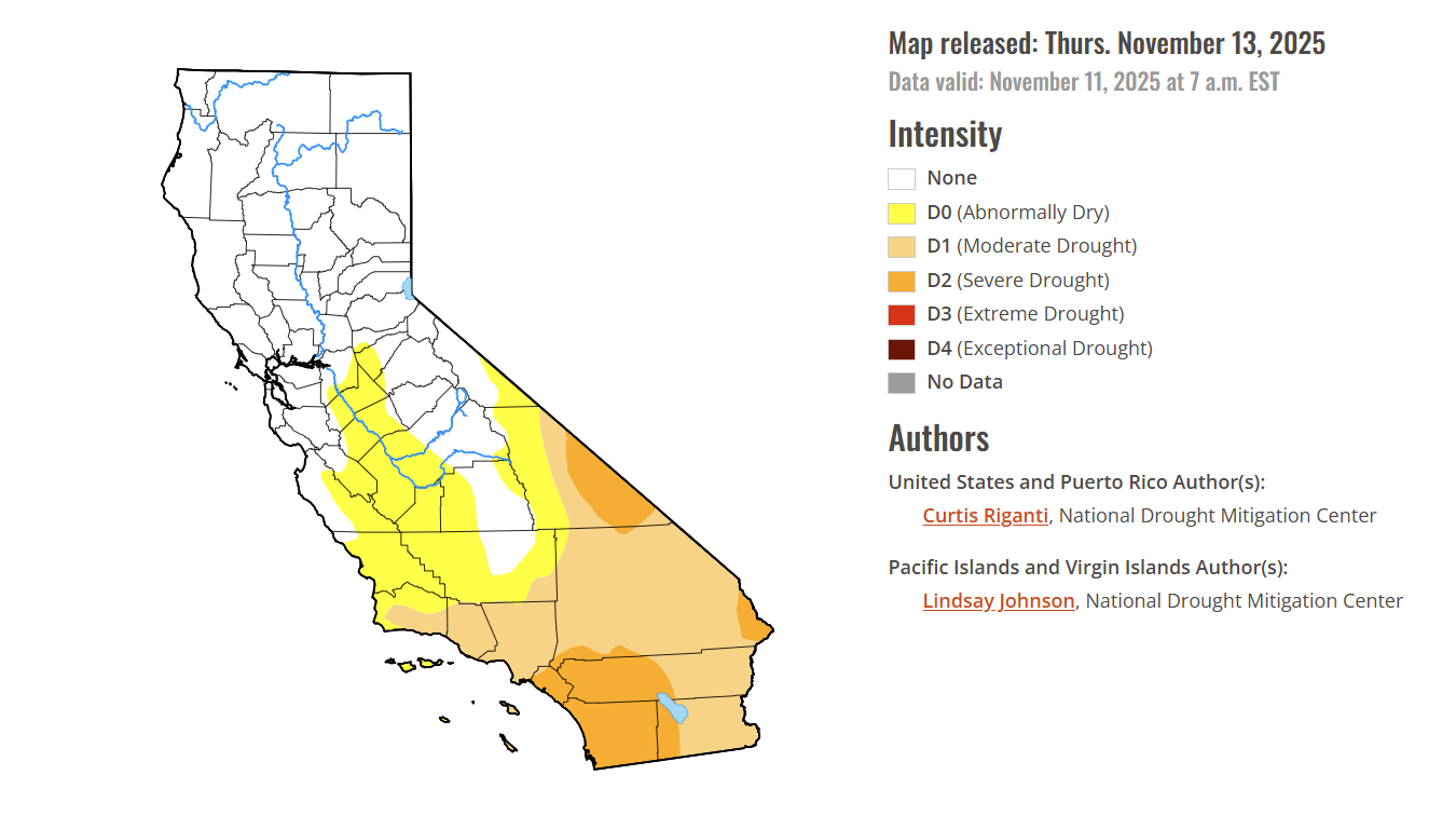
California drought update
Moderate to severe drought was reported in pockets of Southern California with most of the state drought-free, according to Thursday’s Drought Monitor update.
Nine percent of California was in severe drought, the second-least severe of the Monitor’s four drought categories. Areas include most of Orange County, western Riverside County and slivers of San Bernardino County.
About 32 percent of the state was in moderate drought. Nearly 50 percent of California was drought-free.
At this time last year, 5 percent of the state was in severe drought, with 17 percent in moderate drought. Three months ago, near the end of a hot and dry summer, 23 percent of the state was in severe drought with nearly 40 percent in severe drought.
This story uses functionality that may not work in our app. Click here to open the story in your web browser.
![]()
Want more insights? Join Working Title - our career elevating newsletter and get the future of work delivered weekly.
